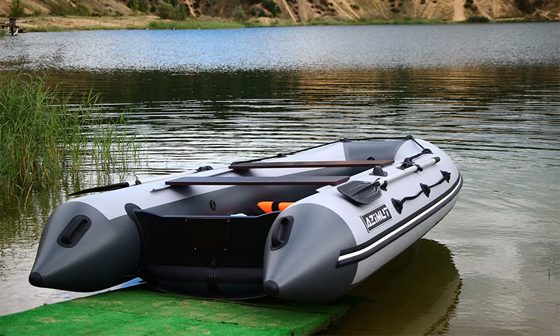
In fact, the tourist navigator consists of components that were endowed with mobile phones in the early 2000s. Such devices have a small display, made by outdated technology, a modest supply of RAM and not the most powerful processor. But more such gadgets and do not need. Much more important is the fact that they show a detailed map of the area, and also have a very good signal reception from satellites.
Content:
Tourist navigator which company to choose
Garmin

The only company that continues to produce massively tourist navigators. Its headquarters is located in the United States, but in Europe there is a separate office - it is located in the UK.
The main feature of the devices from Garmin is the use of very detailed topographic maps. Navigators display every path, every hill, every forest grove ... Also, many Garmin tourist navigators can boast an external antenna, thanks to which there are no problems with signal reception even in small caves.
Best budget travel navigators
Garmin eTrex 10
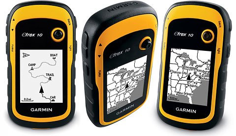
A very modest gadget, the purchase of which should be considered only in case of a shortage of funds for more expensive models. The image here is displayed on a 2.2-inch display with a resolution of 128 x 240 pixels. The screen is monochrome, which already will cause certain difficulties with viewing the map. But on the other hand, such a low-power device functions from a single set of batteries for a very long time. Its case is waterproof, which should save the device even if it falls into a shallow river.
A total of 50 routes can be stored in the memory of the navigator. Each of them can consist of a maximum of 1000 waypoints. An important feature of the device is support for GLONASS. You can regret only about the absence of a slot for a memory card, which is why it is impossible to load additional cards here. Yes, and the internal antenna makes itself felt - from time to time there may be interruptions in signal reception.
Advantages:
- You can save a large number of routes;
- Compact size;
- Waterproof case;
- Long battery life;
- Recognizes signals from GLONASS satellites;
- The minimum weight (142 g).
Disadvantages:
- Internal antenna;
- Monochrome display;
- Not very secure fit;
- In a backpack or pocket there are random movements of the joystick.
Garmin eTrex 30
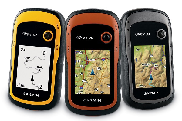
Tourist navigators are very expensive. Garmin eTrex 30 is somewhere at the junction between the budget and the middle price segment. At the same time, the average consumer will be horrified by the cost, because for the same money you can buy a great smartphone. But he definitely will not be able to work in the GPS-navigation mode for 25 hours in a row, while the Garmin product is quite capable of that. And it does not need to be charged - in the future it is enough to change the battery pack, after which you can continue your journey.
Unlike cheaper navigators, eTrex 30 received a magnetic compass and a slot for a memory card. The first greatly simplifies navigation, and the second allows you to download additional maps to the device. And here there is the possibility of data exchange between devices, but this is not so important - it is unlikely in our country you will find another fan of Garmin products nearby. It should also be noted 2.2-inch screen, which became a color. Its resolution is 176 x 220 pixels.
Advantages:
- Color screen, albeit not very large;
- 1.7 GB of internal memory;
- Slot for microSD card;
- There is a magnetic compass;
- Long battery life;
- You can save 200 routes from 2,000 waypoints;
- Protected housing;
- Supported by GLONASS.
Disadvantages:
- Internal antenna;
- Random movements of the joystick in the backpack;
- Slow drawing of the map.
The best tourist navigators of the middle and top price segments
Garmin GPSMAP 64ST
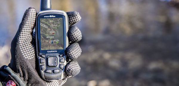
An ideal choice for those who wish to go fishing with a navigator. This device is not afraid of water at all. You can also change cards by downloading to the microSD card more suitable for your purposes. The device has a belt clip that looks quite reliable.
Of the innovations can be noted synchronization with a smartphone via Bluetooth. From time to time, all information will be saved to the phone, with the result that it will remain with you even if the navigator itself is lost somewhere. It also simplifies the user's life by the fact that after the hike you do not need to spend time on the independent transfer of all data.
The diagonal of the color display here has grown to 2.6 inches. But the resolution remains minimal - it is 160 x 240 pixels. But internal components have improved, with the result that the map is not drawn as slowly as on cheaper models. In general, the device most impresses with its reliability. Although in terms of functionality, it is no longer as funny as the younger Garmin products.
Advantages:
- 8 GB of permanent memory;
- The possibility of using a microSD card;
- Saving 200 routes from 10,000 waypoints;
- Powerful antenna;
- The presence of a magnetic compass;
- GLONASS support;
- Interaction with the smartphone;
- Waterproof case;
- Ability to recharge AA-batteries.
Disadvantages:
- Not a very long time;
- Very high cost;
- The screen could be better.
Garmin Astro 320
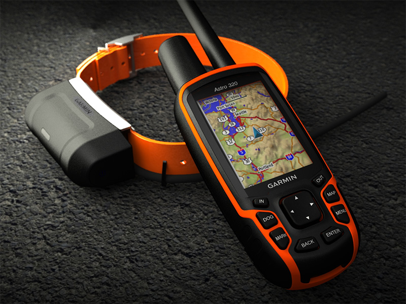
Most of all, this device looks like some kind of walkie-talkie. But there are already used two external antennas, one of which can be disconnected. Such a design allowed not only to improve signal reception, but also to introduce support for EGNOS and WAAS technologies. The manufacturer says that Garmin Astro 320 will display your location, no matter where you are. The only exceptions are when you have fallen deep underground.
The 2.6-inch display installed here has a resolution of 160 x 240 pixels. Traditionally, such low parameters are chosen so that maps are drawn quickly enough. Although many buyers notice that it would be time for Garmin to switch to modern technologies that would improve the picture and leave the battery life the same.
Advantages:
- The presence of a magnetic compass and barometer;
- 200 routes from 200 waypoints;
- 1.66 GB of permanent memory;
- Two very powerful antennas;
- Support for all modern navigation technologies;
- There is a slot for microSD;
- Waterproof case;
- 12 channels of signal reception from other devices;
- Ability to recharge AA-batteries.
Disadvantages:
- Not the best display;
- No interaction with the smartphone;
- Not everyone can afford it.
Garmin monterra
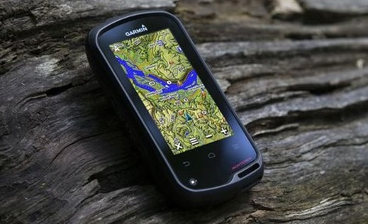
Many will say that this navigator is unreasonably expensive. Even Apple smartphones are cheaper! But they are primarily created for fun, while Garmin Monterra could theoretically save your life! The creators endowed their creation with a moisture-proof and shock-resistant casing, thanks to which even climbers make their choice in favor of their devices. If suddenly there is some kind of trouble - the navigator sends a signal to help other people, using the GSM-module.
For the first time in the history of Garmin, not proprietary firmware is used here, but the Android operating system. At first, it worked very badly, but after the third update, the function became much more stable. The screen here uses a 4-inch LCD panel with a resolution of 272 x 480 pixels. Such a low parameter is chosen in order to ensure an acceptable running time.And yet it is not as high as we would like, especially against the background of the three AA-batteries used here.
Advantages:
- Present modules Bluetooth and Wi-Fi;
- You can install a memory card;
- There is a built-in memory;
- Full Android on board;
- Saving a large number of routes of 10,000 points each;
- Built-in GSM-module;
- The ability to listen to music and use the camera (8 MP);
- GLONASS support;
- Inside there are an accelerometer, a barometric altimeter and a compass;
- Maximum for the tourist navigator functionality.
Disadvantages:
- Three batteries are not enough for long;
- Incredibly high cost;
- In the rain, the screen spontaneously works.
Which tourist navigator to choose
1. If you regularly happen to nature in unfamiliar areas, then you can not do without a tourist navigator. Of course, you can try using a smartphone. But it will be discharged faster, and its maps will surely be less detailed. And the smartphone does not have an altimeter and some other sensors, which are available in Garmin Monterra and some other most expensive GPS-navigators.
2. If you do not have the money for such an expensive toy, you can take a look at the Garmin GPSMAP 64ST. This is also not a budget option, but you get a good screen, confident signal reception and instant drawing of maps. Something similar offers and Garmin Astro 320, which has two antennas and the ability to receive signals from GPS transmitters (which, for example, embedded in the collar, worn on the hounds).
3. As for the cheaper options, there are no solutions among them that could be called a justified purchase. Garmin eTrex 10 will quickly disappoint you with the inability to load other maps, as well as its slowness. Garmin eTrex 30 in this regard shows itself from a slightly better side. But fast this navigator can not be called yet. And we must not forget that Garmin has quite a lot of offers in this price category, but they are all approximately equivalent.
It will be interesting to friends too